Sunday, April 21, 2024

Map Update: Sweden Joins NATO

Map of NATO allies in 2024, with all members color-coded in dark blue including the newest country to join, Sweden.  Also labels Russia, whose invasion of Ukraine led to Sweden and neighboring Finland choosing to join. The map is projected to appear as if the viewer is looking at a globe, with the North Atlantic Ocean in the center. The left side is dominated by large NATO members the US and Canada, while on the right side the smaller continent of Europe is mostly made up of blue NATO member countries, with a few noticeable gaps. Sweden is located near the upper-right corner, filling in what was previously a large hole in the NATO area, surrounded by member countries Finland, Norway, and (across a narrow strip of sea) Denmark, Germany, Poland, and the Baltic countries. Colorblind accessible.


Graphic modified by Evan Centanni from this map by Wikimedia user Addicted04 (CC BY-SA).

New NATO Ally: Sweden

Northern Europe's Kingdom of Sweden was admitted last month as a full member of the North Atlantic Treaty Organization (NATO), a military alliance of countries in Europe and North America, famous for its opposition to the Russia-led "Communist Bloc" in the 1947-1991 Cold War. Sweden's NATO membership officially went into effect on March 7 after the final paperwork and exchange of documents were completed. Sweden is the 32nd country to join NATO.

Sweden, which had positioned itself as a more-or-less neutral country in the Cold War, chose to join the historically anti-Russia alliance after Russia's full-scale invasion of Ukraine. Sweden applied for membership in 2022 at the same time as neighboring Finland, but took almost a year longer to overcome objections from existing NATO members Türkiye (Turkey) and Hungary.

Saturday, March 9, 2024

Israel / Palestine: Map of Control on March 4, 2024 (Subscription)

SUBSCRIBERS CLICK HERE TO VIEW FULL ARTICLE AND MAP:
Old Portal (members.polgeonow.com) | New Portal (controlmaps.polgeonow.com)


(To see more maps in this series, view all Israel articles or Palestine articles on PolGeoNow.)

Map by Evan Centanni, timeline by Djordje Djukic with Evan Centanni

Subscribe for full access to all conflict map reports!

Thumbnail preview of map of who controlled Palestine and Israel's claimed territories on March 4, 2024, four months into the Israeli (IDF) ground invasion of the Gaza Strip, and before the threatened assault on Rafah. Shows both Israeli and Palestinian Authority administration (Fatah and Hamas factions indicated separately). Includes bigger West Bank map (Area A, Area B, and Area C). Map also includes Gaza Strip, Golan Heights, major cities and Israeli settlements, UN peacekeeper deployments (UNIFIL in Lebanon and UNDOF in Syria), no man's land, Golan Heights buffer zone (area of separation, AOS), and Shebaa Farms. New edition also shows so-called Gaza Envelope and Confrontation Line zones, the areas of Israel proper are under the greatest military restrictions. Includes all major cities and various key towns and sites from the news, like Khan Yunis, Jabalia (Jabaliya), Maghazi Refugee Camp, Abasan al-Kabira, Kerem Shalom crossing, Jenin, Tulkarm, and more. Now with improved colorblind accessibility.

In the past three months, Israel's counter-invasion of the Gaza Strip has slowly ground on, with the shift focusing from Gaza City in the north to Khan Yunis in the south, and possibly to Rafah next. However, much of the Strip still remains outside of Israeli control, while closely-related violence continues at a lower level in the West Bank, on the Lebanon border, and as far afield as Yemen and Iraq.

See all this and more in the latest update to PolGeoNow's widely-acclaimed map of territorial administration in the Israel/Palestine area. In addition to the updated map, the report also includes a detailed chronicle of changes and events since December 8, 2023, the date illustrated by our previous Israel/Palestine control map.

This map and report are premium content, available to paid subscribers of the PolGeoNow Conflict Mapping Service.

Want to see before you subscribe? Check out our most recent FREE SAMPLE Israel/Palestine map report!

Exclusive map report includes:

  • Up-to-date illustration of current territorial control across all areas claimed by either Israel or Palestine, including Hamas and Israeli military control in the Gaza Strip (not in extreme detail), as well as UN peacekeeper deployments just outside the region
  • Closer-up inset map showing the divisions in the West Bank: Israeli military control (including Jewish settlements), Fatah-led Palestinian jurisdiction, areas of shared administration, and the (annexed) area of Israeli civilian control in East Jerusalem
  • Lines illustrating the pre-1967 ceasefire boundaries separating Israel proper from the Palestinian-claimed Gaza Strip and West Bank, as well as the Syria-claimed Golan Heights
  • Labels for contentious areas, like the Gaza Strip, West Bank, Golan Heights, Shebaa Farms, and "no man's land"
  • Illustration of which parts of Israel proper are subject to the greatest restrictions by military decree under current war powers: the "Gaza Envelope" in the south and the "Confrontation Line" in the north
  • Detailed indication of city-by-city control, including key towns and other locations important to current events, including in the West Bank and along the border with Israel and Lebanon
  • Locations of recent control changes and other important events, including Khan Yunis, Jabalia (Jabaliya), Maghazi Refugee Camp, Abasan al-Kabira, Kerem Shalom crossing, Jenin, Tulkarm, and more.
  • Detailed timeline of important events and changes to territorial control since December 8, 2023, with links to sources.
  • Additional timeline entries chronicling events in all four additional fronts to the conflict: (1) the Lebanon border, where Israel and Hezbollah are engaged in cross-border attacks; (2) the West Bank, where near-daily Israeli raids on Palestinian-governed cities have led to intense clashes; (3) attacks on Western shipping in the Red Sea and Gulf of Aden near Yemen, where the US and UK have retaliated militarily against the "Houthi" government; and (4) tit-for-tat attacks between Iran-backed militias and the US and Israel in Syria and Iraq (Fronts 3 and 4 are not illustrated on the map).

SUBSCRIBERS CLICK HERE TO VIEW FULL ARTICLE AND MAP:
Old Portal (members.polgeonow.com) | New Portal (controlmaps.polgeonow.com)


Not signed up yet? Click here to learn more about our professional subscription service!

Can I purchase just this map?
This map and report are not available for automated purchase to non-subscribers. If you need access or republication rights for only this map report, contact service@polgeonow.com for options.

Friday, March 1, 2024

Ukraine: Map & Timeline of Russian Control in October 2023

(To see other maps in this series, view all Ukraine articles on PolGeoNow.) Hidden image for crawlers

Map of Russian-controlled territory in Ukraine on October 9, 2023. In addition to the Crimean peninsula, which Russia had already seized in 2014, and parts of the far eastern Donetsk and Luhansk provinces (the Donbas region) already controlled by Russia-backed separatist rebels (and formerly declared independent as the Donetsk and Lugansk People's Republics), Russian forces still controlled a wide belt of territory just north of Crimea, including large parts of Kherson and Zaporizhzhia provinces, as well as large additional areas of Donetsk and Luhansk provinces. Meanwhile, all of those provinces are now claimed by the Russian government as parts of Russia, creating a new claimed international border through what was until recently undisputed eastern Ukraine. From August to October 2023, Ukraine made some small advances, capturing two or three significant towns from Russian forces. Map includes key locations from the news, such as Robotyne, Synkivka, Sevastopol, Verbove, and more. Colorblind accessible.
Map by Evan Centanni and Djordje Djukic. Contact us for permission to use this map.

Timeline by Djordje Djukic

Map of territorial control within the claimed borders of the self-declared Donetsk People's Republic (DPR) and Lugansk People's Republic (LPR), which now consider themselves part of Russia, updated to October 9, 2023, months into Ukraine's 2023 counteroffensive. Map shows that the vast majority of the LPR, otherwise known as Ukraine's Luhansk province, is now under the control of Russia, while Russian forces also control over half of the DPR, or Ukraine's Donetsk province, including the major central and southern cities of Donetsk, Horlivka, Makiyivka, and Mariupol. Includes key locations from the news, such as Klischivka, Yakovlivka, Avdiivka, Marinka, Karmazynivka, and many more. Colorblind accessible.
Map showing what parts of the claimed territory of the self-declared Donetsk and Lugansk People's Republics - now claimed as part of Russia - are controlled by Russian forces and allies, compared to the Ukrainian government. Click to enlarge. Map by Evan Centanni and Djordje Djukic. Contact us for permission to use this map.

Ukraine retakes towns amid slow-going counteroffensive

(The maps in this report show the situation as of October 9, 2023. Further territorial changes will be covered in an upcoming update.) 

Between our previous Ukraine control map of August 2023 and early October, Ukrainian forces managed to secure control of some significant towns and other locations from their Russian opponents, despite Russia having gained more ground overall since the beginning of the year.

Ukraine's capture of Robotyne town in Zaporizhzhia province marked a small step in its efforts to break the Russian "land bridge" of territory connecting Crimea and Donetsk, the focus of Ukraine's much-hyped but ultimately bloody and anticlimactic 2023 counteroffensive.

Meanwhile, the northeastern town of Synkivka was restored to full Ukrainian control after being partly occupied by Russian forces, and Klischivka town, south of the small eastern city of Bakhmut, was captured by Ukraine. In the Black Sea, Ukraine brought the war to the Russian stronghold of Crimea, capturing offshore oil rigs and launching damaging attacks on Russia's navy in Sevastopol.

Saturday, February 10, 2024

Sudan Control Map & Timeline: RSF Takes Darfur Cities - Dec. 2023 (Subscription)

SUBSCRIBERS CLICK HERE TO VIEW FULL ARTICLE AND MAP:
Old Portal (members.polgeonow.com) | New Portal (controlmaps.polgeonow.com)


(To see other maps in this series, view all Sudan articles on PolGeoNow.)

Map and article by Evan Centanni and Djordje Djukic

Subscribe for full access to all conflict map reports!

Sudan War: Thumbnail preview of map of who controlled what in Sudan on December 5, 2023. Best Sudan control map online, thoroughly researched for maximum accuracy. Shows territorial control by the government-affiliated Sudanese Armed Forces (SAF), the Rapid Support Forces (RSF) paramilitary group, and rebel groups in Sudan including the Sudan Liberation Army/Movement's Abdelwahid El Nur faction (SLA-AW/SLM-AW) in Darfur's Jebel Marra, the SPLM-N faction of Abdelaziz El Hilu in the Two Areas of South Kordofan (Nuba Mountains) and Blue Nile. Also shows the area of control of the Ngok Dinka Abyei Area Administration (AAA) within the disputed Abyei Box. Includes disputed territories claimed by other countries, including the Halaib Triangle, Bir Tawil, and Wadi Halfa Salient along the border with Egypt, plus Kafia Kingi, 14-mile, Abyei, Heglig, Kaka, and Bebnis along the South Sudan border, showing which parts are controlled by which country. Includes key cities and other locations from the news, including Nyala, Zalingei, Ed Daein, Ardamata, Balila oil field, Shag Omar oil field, Babanusa, Um Rawaba and many more.

From October to December of 2023, the defiant Rapid Support Forces (RSF) paramilitary group accomplished a massive consolidation of control in western Sudan's Darfur region. By early December, the country’s official military had lost its footholds in four out of five of the region's state capitals - though the RSF's control of Darfur was still not as complete as most reports implied.

(This second edition of our new Sudan map series depicts control in early December 2023, based on research conducted through January of 2024. Another edition, showing the current situation in 2024, will be coming in the near future.)

See all this and more in the latest update to PolGeoNow's rigorously-researched and exhaustively cited Sudan control map and report - the most precise and accurate available online. In addition to the updated map, the report also includes a detailed chronicle of changes and events since October 9, 2023, the date illustrated by our earlier Sudan control map.

This map and report are premium content, available to paid subscribers of the PolGeoNow Conflict Mapping Service.

Want to see before you subscribe? Check out our most recent FREE SAMPLE Sudan map report!

Exclusive map report includes:

  • Up-to-date illustration of current territorial control in Sudan's new civil war between the Sudanese Armed Forces (official government military) and Rapid Support Forces (RSF) paramilitary group, rigorously corroborated, with areas of ambiguity clearly indicated. 
  • Detailed and carefully-researched illustration of territorial control by Sudan's two major "holdout" rebel forces from before the 2023 war: SPLM-N El Hilu in South Kordofan and Blue Nile states, and the SLA-AW (SLM-AW) in Darfur's Jebel Marra.
  • Thoroughly-researched depictions of each disputed territory claimed by Sudan along the Egyptian and South Sudanese borders, marking which parts are controlled by the other countries and which parts by other groups (e.g. UN peacekeepers and the Ngok Dinka "Abyei Area Administration").
  • Detailed indication of city-by-city control, including key towns and other locations important to current events
  • Locations of recent control changes and other important events, including Nyala, Zalingei, Ed Daein, Ardamata, Balila oil field, Shag Omar oil field, Babanusa, Um Rawaba, and more.
  • Detailed timeline of important events and changes to territorial control from October 9 to December 5, 2023, with links to sources.

SUBSCRIBERS CLICK HERE TO VIEW FULL ARTICLE AND MAP:
Old Portal (members.polgeonow.com) | New Portal (controlmaps.polgeonow.com)


Not signed up yet? Click here to learn more about our professional subscription service!

Can I purchase just this map?
This map and report are not available for automated purchase to non-subscribers. If you need access or republication rights for only this map report, contact service@polgeonow.com for options.

Sudan War Control Map & Timeline - October 2023

There are later versions of this map available. To see them, view all Sudan articles on PolGeoNow.

PolGeoNow proudly presents the first edition of our new Sudan war map series, meticulously researched over many months. We believe these to be the most accurate Sudan control maps available anywhere.

This edition of the map depicts control in early October 2023, based on research conducted through January of 2024. A map of control in December 2023 has been released to our paid subscribers, and we intend to publish another free edition soon showing the current situation in 2024.

Sudan War: Map of who controlled what in Sudan on October 9, 2023. Best Sudan control map online, thoroughly researched for maximum accuracy. Shows territorial control by the government-affiliated Sudanese Armed Forces (SAF), the Rapid Support Forces (RSF) paramilitary group, and rebel groups in Sudan including the Sudan Liberation Army/Movement's Abdelwahid El Nur faction (SLA-AW/SLM-AW) in Darfur's Jebel Marra, the SPLM-N faction of Abdelaziz El Hilu in the Two Areas of South Kordofan (Nuba Mountains) and Blue Nile. Also shows the area of control of the Ngok Dinka Abyei Area Administration (AAA) within the disputed Abyei Box. Includes disputed territories claimed by other countries, including the Halaib Triangle, Bir Tawil, and Wadi Halfa Salient along the border with Egypt, as well as Kafia Kingi, 14-mile, Abyei, Heglig, Kaka, and Bebnis along the South Sudan border, showing which parts are controlled by which country. Includes key cities and other locations from the news, including Khartoum, Omdurman, El Fasher, Nyala, Geneina, Zalingei, Shag Omar oil field, Babanusa, Dibebad, Kadugli, Um Rawaba, Dilling, Bahri, Wad Rawa, Kurmuk, and many more.
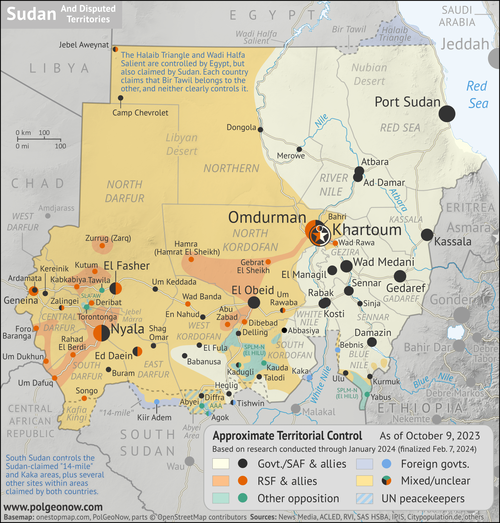
Map by Evan Centanni and Djordje Djukic, starting from base map by Koen Adams of onestopmap.com. See article below for a detailed accounting of which groups are included in each territorial control category. To use this map in your own materials, please contact us to arrange permission.

Timeline by Djordje Djukic and Evan Centanni

Unknown Territory: Sudan’s New Civil War 

In April 2023, a new civil war broke out in Sudan (officially “the Sudan”)*, pitting the country’s official military, the Sudanese Armed Forces (SAF), against the Rapid Support Forces (RSF), a powerful government-affiliated paramilitary group. Sudan has fought more than one civil war before, but never in its traditional heartland along the River Nile. This new conflict is said to be the first in “at least a hundred years” where control of the capital city, Khartoum, is clearly in the balance. 

Unlike previous wars, the new conflict is essentially a power struggle among members of Sudan’s majority cultural group, the “Arab” people - and yet, analysts say it’s still a continuation of the long-running clash between the country’s central core and outer regions. The RSF’s leadership, and most of its fighters, come from the nomadic Arab communities of Sudan’s Darfur region in the west, who were integrated into Arab culture later in history than the Nile elites, and until recently held little power in the national government. (See below for further discussion of these and other conflict dynamics.)

With at least 13,000 dead as of December 2024, the war is also one of the deadliest in the world today, on par with the Myanmar conflict and only far-surpassed in 2023 by the wars in Ukraine and Israel/Palestine. Many thousands of civilians are among the dead, with the United Nations documenting indiscriminate SAF airstrikes in major cities, while also describing an apparent campaign of genocide by the RSF and allies against non-Arab citizens of West Darfur state.